

A receiver determines location by turning precisely timed satellite signals into measurements of distance, then solving those measurements against known satellite positions. That sounds straightforward, but a professional positioning workflow involves several stages: signal acquisition, timing comparison, satellite geometry, correction data, and coordinate calculation.
The distinction becomes especially important when centimeter-level results are required for surveying, construction, machine guidance, or other precision applications.
Satellite Signals Provide the Measurements, Not the Final Position
Navigation satellites continuously transmit signals containing timing and orbital information. A receiver captures signals from multiple satellites and compares the transmission time encoded in each signal with the time at which it is received. The resulting difference is used to estimate how far the receiver is from each satellite.
One satellite can define a possible distance from the receiver, but it cannot identify a unique three-dimensional position. Multiple satellites create intersecting distance constraints, allowing the receiver to solve for latitude, longitude, height, and receiver clock offset. This basic calculation is known as trilateration.
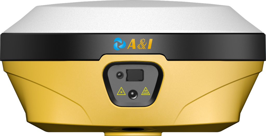
A GPS GNSS receiver can track signals from multiple satellite constellations rather than relying only on the GPS system. The AL16 is identified as a geodetic GNSS receiver, while Archimedes Innovation lists AL16 Laser RTK among its GNSS receiver products. This multi-constellation approach can provide the measurement diversity needed for professional positioning workflows.
Why Satellite Distance Measurements Are Not Perfectly Exact?
The calculated distance is not a perfect physical measurement. Satellite and receiver clocks introduce timing uncertainty, while the signal travels through the atmosphere before reaching the antenna. Multipath can also affect the measurement when signals reflect from nearby surfaces.
Satellite geometry matters as well. Even accurate individual measurements can produce a less favorable position solution when visible satellites are arranged poorly. Consequently, positioning performance depends on more than simply counting satellites.
A receiver processes these observations through positioning algorithms to estimate the most consistent location. Standard single-point positioning can provide meter-level results, while differential techniques can substantially improve accuracy by using information from a known reference.
How an RTK Receiver Reaches Centimeter-Level Positioning?
Real-Time Kinematic, or RTK, improves positioning by using carrier-phase observations and correction information from a reference station or network. The rover receives both satellite observations and correction data, allowing common errors between the reference and rover to be reduced.
The central difference is that RTK does not rely only on the raw distance estimates derived from signal timing. Carrier phase provides a much more precise measurement of the signal’s relative position within its wavelength. The difficult part is resolving the integer ambiguity associated with the number of complete carrier cycles between satellite and receiver.
Once the ambiguity is successfully resolved, the system can produce a fixed RTK solution. Archimedes Innovation’s published M992-INS specifications, for example, list RTK accuracy of 0.8 cm + 1 ppm horizontally and 1.5 cm + 1 ppm vertically. Those figures are product-specific specifications rather than a universal performance level for every RTK system.
What Correction Data Changes in the Calculation?
Correction data gives the rover additional information about errors affecting the satellite measurements. A reference station has a known position, so it can compare its expected measurements with its observed measurements and generate correction information for a rover.
The rover applies those corrections while continuing to observe the satellites itself. Communication between the reference and rover may use radio, cellular networks, or other data links depending on the system architecture.
The AL16 user documentation describes differential data from a base station as part of the high-precision positioning process. It also includes point calibration functions for cases where a self-built base station’s coordinates need to be aligned with known coordinates.
This explains why an RTK receiver is normally part of a larger positioning workflow rather than a standalone accuracy device. Antenna setup, correction availability, satellite visibility, coordinate reference systems, and field procedures can all influence the final result.
From Satellite Observations to a Usable Survey Coordinate
The calculated position initially exists within a global geographic reference framework. Professional field applications may require that position to be transformed into a local coordinate system used for design drawings, construction control, or existing survey data.
The AL16 user manual describes localization functions that convert high-precision latitude and longitude into ground-plane coordinates. It supports methods including plane correction, vertical correction, elevation fitting, and seven-parameter transformations, with control points used to calculate and evaluate the required parameters.
Archimedes Innovation’s AL16 is also described as supporting laser measurement, AR stakeout, and tilt compensation, extending the positioning workflow beyond the initial satellite calculation.
These functions illustrate an important engineering point: the useful output is not merely a coordinate, but location information that can be applied directly within a field workflow.
For surveying and construction teams, understanding this chain helps explain why a high-precision receiver requires more than a strong satellite signal. The system must acquire suitable observations, solve the measurements, use appropriate corrections, resolve ambiguities where applicable, and convert the resulting position into the coordinate framework required by the project.
Ultimately, a GPS GNSS receiver calculates location by solving relationships between known satellite positions and measured signal information. An RTK receiver adds reference-based corrections and carrier-phase processing to refine that solution substantially.
By incorporating computed coordinates into a larger field workflow, Archimedes Innovation‘s AL16 shows how this positioning foundation may facilitate stakeout, measurement, and surveying operations.
